Medellin, Colombia
Medellin is the capital of the Department of Antioquia and the second largest city in Colombia after Bogotá. It is divided into 16 comunas (urban areas), with 271 barrios, and 5 corregimientos (rural areas). It is a city with a territorial extension closer to the city of Buenos Aires, but with a lower population density, like the city of Sao Paulo.
2.6
million people
376.4
km²
territorial extension
7050
inhabitants/km²
Comuna 2
Comuna 2
Precarious settlements are urban and rural areas that have incomplete and inadequate development conditions in terms of effective access to public and social goods and services considered essential for the satisfaction of personal and collective needs and aspirations, such as education, health, housing, work, a healthy environment, human security, information and participation, generating conditions of low quality of life and situations of inequality and social exclusion.
They are concentrated in what are commonly known as barrios populares or barrios de ladera, which in turn are the result of a combination of pirate allotments and invasions.
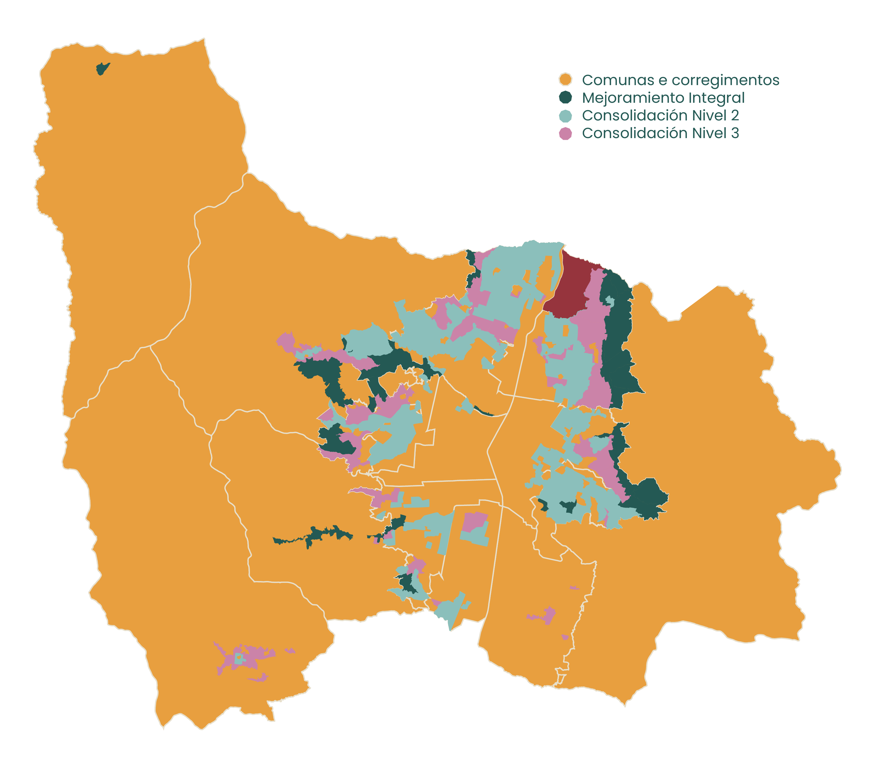
For urban and housing planning purposes, unlike in Sao Paulo and Buenos Aires, they are not classified according to their origin (with boundaries that are increasingly difficult to define), but according to the level of inadequacy to be remedied and the planned urban treatment: Mejoramiento Integral (Integral Improvement – MI) and Consolidación Nivel 3 (Consolidation Level 3 – CN3), which require the preparation of Urban Regularization and Legalization Projects.
The precarious settlements occupy 2,588.89 hectares, or about 6.79% of the total area of the municipality and 22.92% of the urban area (PEHMED 2030). It is estimated that about 33% of the households in the urban area are situated in precarious settlements.
The loteos piratas (pirate allotments) are similar to the irregular allotments in Sao Paulo. They are allotments opened on private or illegally appropriated land, with roads for traffic and future expansion of the service network, which generally do not follow urban planning regulations and were therefore marketed without the approval of the public authorities.
The invasiones (invasions) are similar to the favelas of Sao Paulo or the villas of Buenos Aires, characterized by a lack of land ownership and an urban fabric with no apparent regularity, resulting from spontaneous processes of land occupation.
It is the treatment indicated for settlements that present: critical environmental degradation; irregular occupation and inadequate land use; areas of natural and man-made risk and environmental protection; lack of public household services, especially drinking water and sanitation; disarticulation of mobility and transportation systems; deficit of public space and high densities; low coverage and quality of public facilities and services for education, health, culture, sports and leisure, and inadequate housing conditions.
- 26 polygons of urban land and around 1,103 ha (ISVIMED, 2019)
- Approximately 85,681 households (DAP, 2015)
- 26 polígonos em solo urbano e cerca de 1.103 ha (ISVIMED, 2019)
- Cerca de 85.681 domicílios (DAP, 2015)
This is the treatment given to areas, usually with a high density of housing, that have inadequate provision of infrastructure, public space and facilities.
- 41 polygons of urban land and about 1,445 ha (ISVIMED, 2019)
- About 167,332 households (DAP, 2015)